
Study Guides
IB DP Geography: Unit 4: Power, places and networks – Study Guide
Global power, networks and flows, and the human and physical influences on global interactions, taught for the Higher Level extension of IB Diploma Programme Geography.
- Subject
- Geography
- Level
- IB
- Topic
- Unit 4: Power, places and networks
- Author
- Marlbridge Academic Team
- Updated
- Reviewed by
- Azam Siddique (what this means)
Aligned to International Baccalaureate IB Diploma Programme Geography (DP Geography), First assessments 2019. Official specification .
Syllabus page (what it covers and how it is assessed): IB Diploma Programme Geography.
Syllabus points this page covers
DP Geography
- 11.1 Global interactions and global power
- 11.2 Global networks and flows
- 11.3 Human and physical influences on global interactions
This page covers all 3 subtopics recorded here in topic 11, Unit 4: Power, places and networks.
This guide covers Unit 4, Power, places and networks, the first of the three units that make up the Higher Level extension of IB Diploma Programme Geography (first assessments 2019). The extension is about global interactions: how places are drawn together by trade, finance, migration and information, and who gains or loses influence as a result. Because the extension is examined at HL, the expectation is not only that you can describe interactions but that you can evaluate them, using real places and processes as evidence.
Where this fits in the course
Unit 4 sets the framework that Units 5 and 6 then use. Unit 5 asks what these interactions mean for human development and cultural identity, and Unit 6 asks what risks they create and how societies build resilience. If you are secure on the language of power, flows and networks, the later units become application rather than new theory. Throughout, the course asks you to think in geographic concepts such as power, place, space, scale and interdependence, and to write about real case studies rather than generalities.
11.1 Global interactions and global power
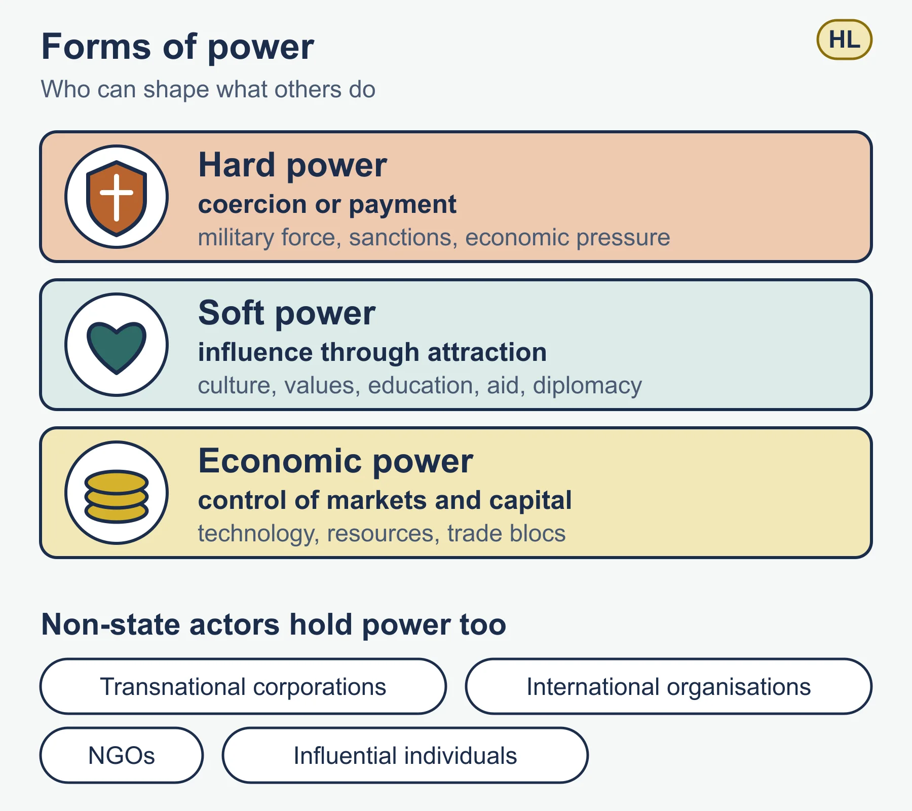
Power in geography is the ability of a state, organisation or group to influence the behaviour of others or to shape outcomes. It is exercised in several forms.
- Hard power uses coercion or payment: military force, sanctions, economic pressure.
- Soft power, a term associated with the political scientist Joseph Nye, is influence through attraction: culture, values, education, foreign aid and diplomacy.
- Economic power comes from control of markets, capital, technology and resources, and from membership of institutions such as trade blocs.
States are often grouped as superpowers, emerging powers and a wider set of dependent or peripheral states, but you should treat these categories as a debate rather than a fixed list. Power is also exercised by non-state actors: transnational corporations (TNCs), international organisations, non-governmental organisations and influential individuals. A strong answer shows that power is plural and contested.
Useful ideas to be able to explain and apply:
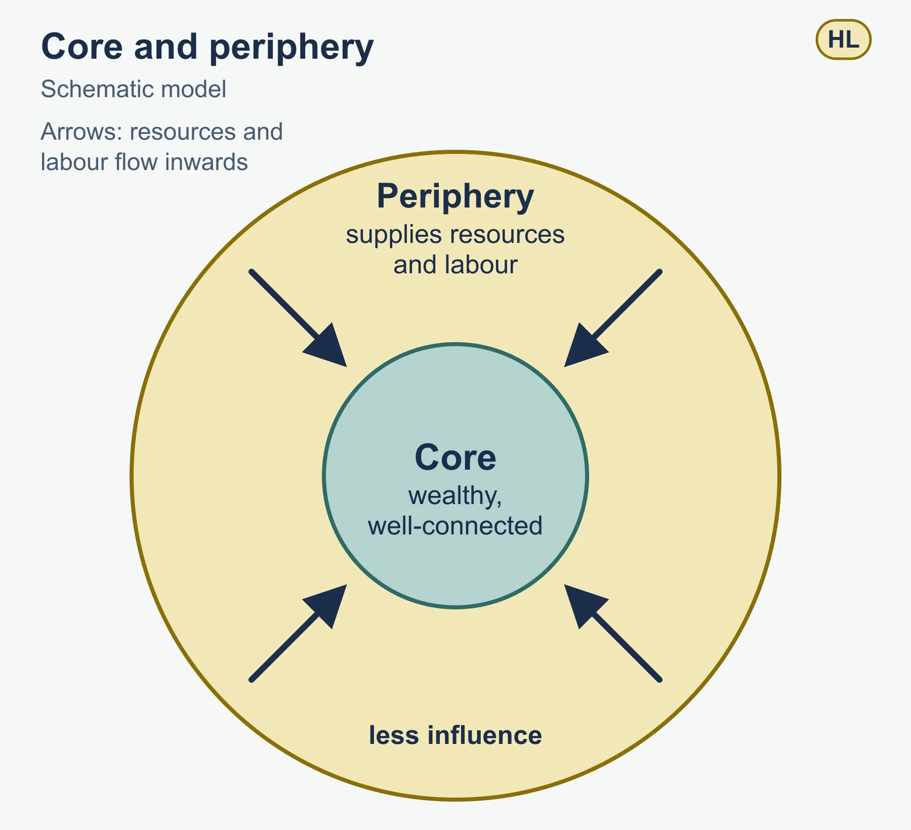
- Core and periphery: a core of wealthy, well-connected places and a periphery that supplies resources or labour and has less influence.
- Changing power over time: power shifts as economies grow, as alliances change and as technology alters who can project influence. Mackinder’s heartland idea of 1904 is an early geopolitical theory that links physical geography to power, and it is worth knowing as a historical example, though you should criticise it as dated.
- Interdependence: states that trade and invest heavily with each other are bound together, which can restrain conflict but also transmits shocks.
11.2 Global networks and flows
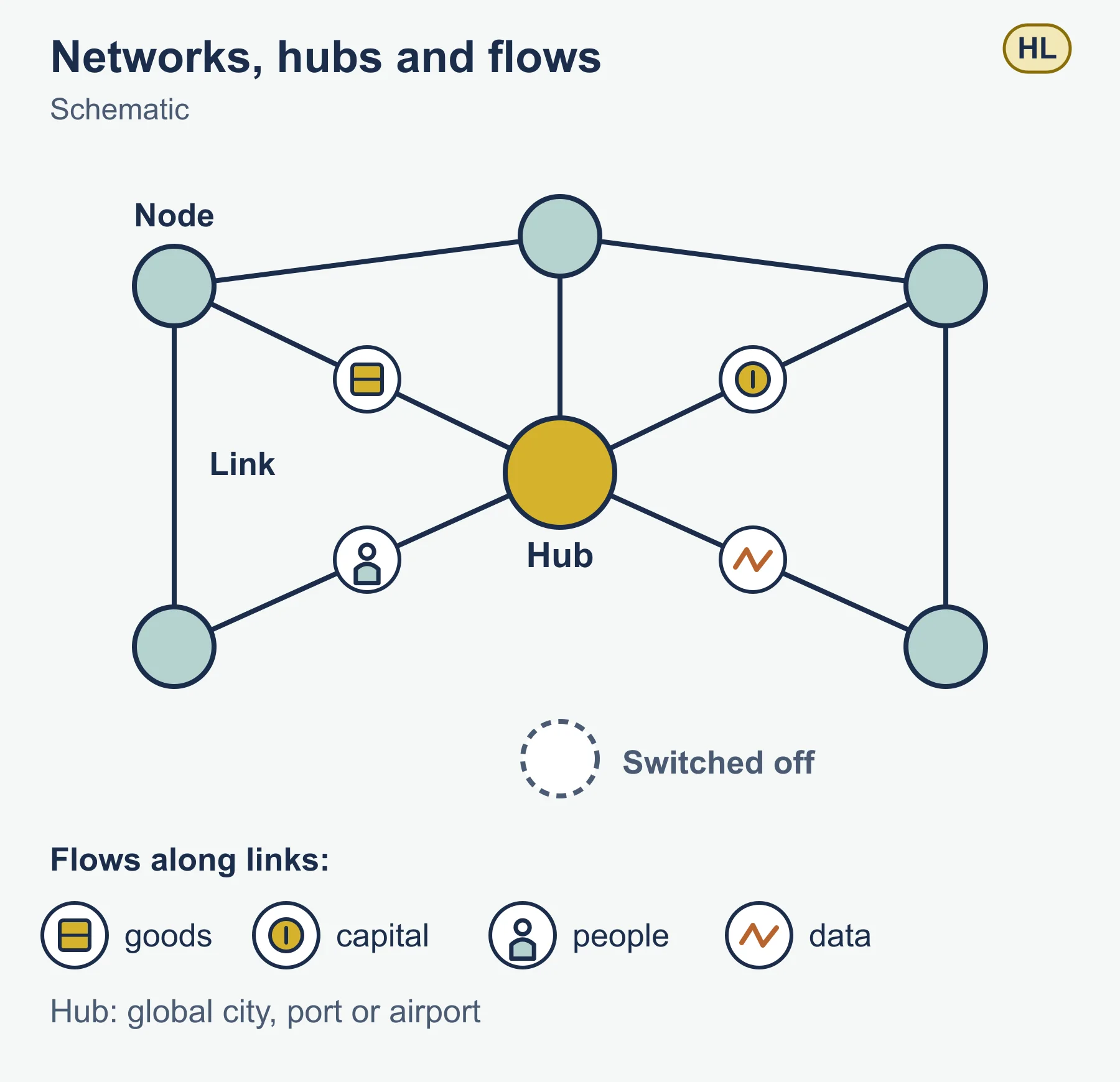
A network is a set of nodes (places) linked by connections; a flow is the movement along those links of goods, capital, people, ideas, data or services. Globalisation can be described as the intensification of these flows and the growing connection of distant places.
Key points for this subtopic:
- Types of flow: trade in goods and services, foreign direct investment, remittances, migration, tourism, information and communication flows, and flows of culture.
- Time-space compression, a phrase from David Harvey, describes how transport and communication technology shrink the effective distance between places.
- Nodes and hubs: global cities, ports and airports concentrate flows and so concentrate influence. Places that are poorly connected can be described as switched off from the main networks.
- Transnational corporations organise production across borders, placing design, assembly and sales in different countries according to costs and markets. This produces global production networks.
- Gatekeepers: governments, institutions and corporations decide who can access a network, which links power back to connection.
Measuring connection is part of the work. Indices of globalisation combine economic, social and political indicators, and you can discuss how far any single index captures reality. Always comment on what an index leaves out.
11.3 Human and physical influences on global interactions
Not every place is connected equally, and the reasons are both human and physical.
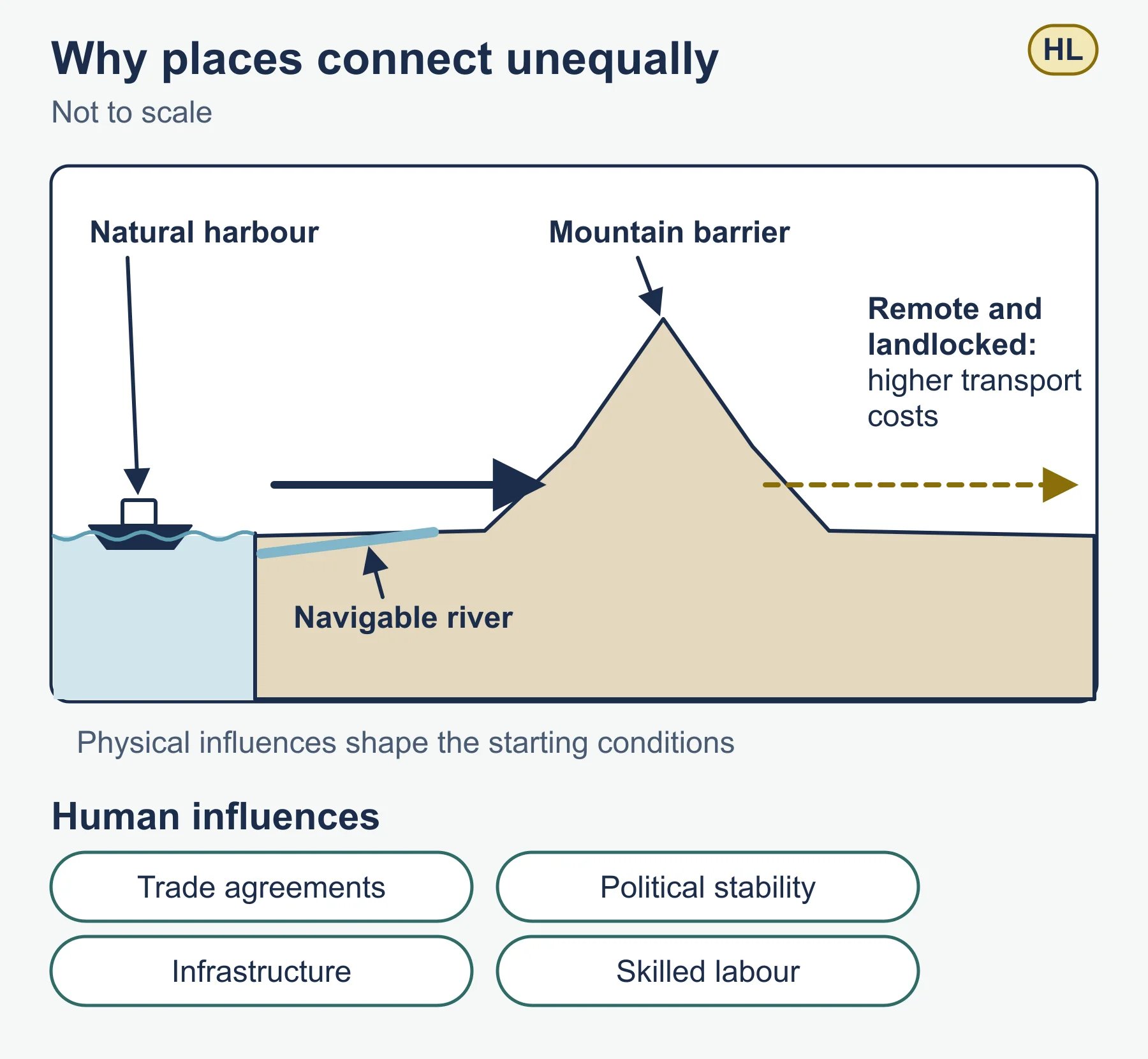
- Human influences: government policy and trade agreements, political stability, infrastructure investment, the cost of transport, language and cultural ties, colonial history, and the presence of skilled labour.
- Physical influences: location on coasts or navigable rivers, mountain and desert barriers, climate, natural harbours, and resource endowment. Physical geography rarely decides outcomes alone, because technology and policy can overcome many barriers, but it shapes the starting conditions.
- Distance and accessibility: places that are remote or landlocked often face higher transport costs and therefore lower participation in trade.
- Barriers and filters: tariffs, border controls, censorship and conflict slow or block flows.
The gravity model is a simple way to express how interaction depends on size and distance: interaction between two places is proportional to the product of their sizes divided by the square of the distance between them. It is a model, so you should note its assumptions and limits.
Worked example: applying the gravity model
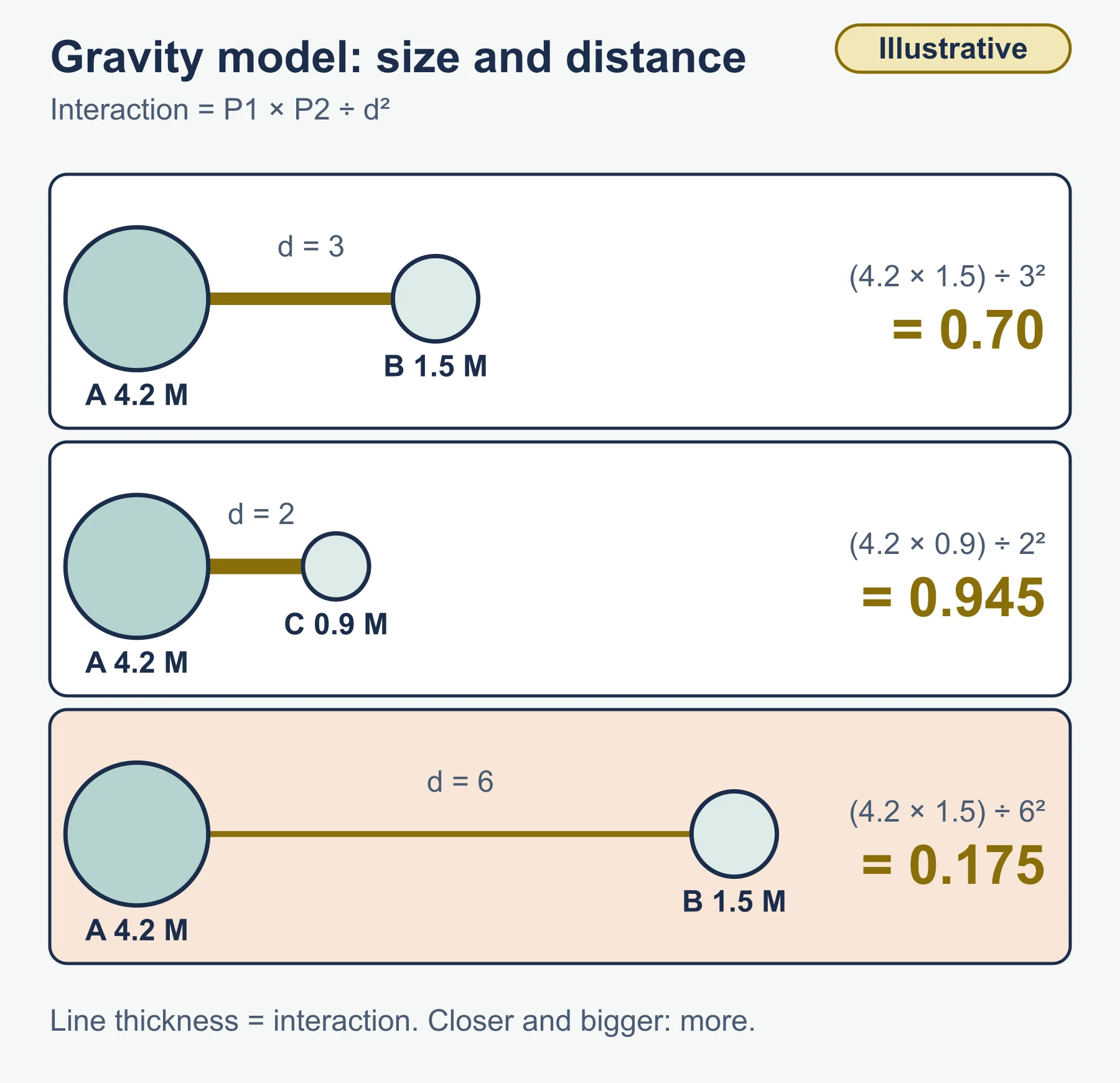
Use the simple form: interaction = (P1 x P2) / d squared, where P is population in millions and d is distance in hundreds of kilometres. The numbers below are invented for practice.
- City A has 4.2 million people, city B has 1.5 million, and they are 300 km apart (d = 3).
- City A and city C: C has 0.9 million people and is 200 km from A (d = 2).
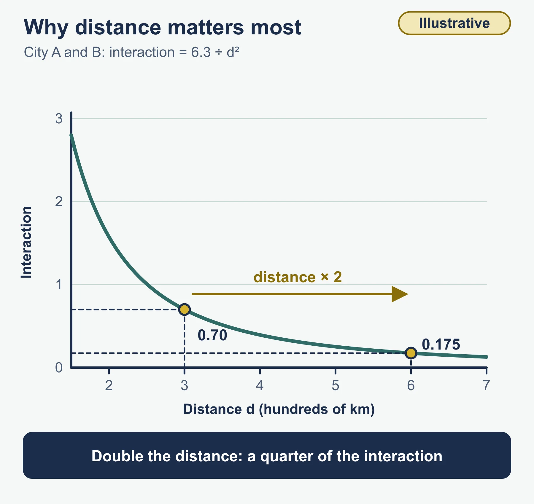
Interaction A-B = (4.2 x 1.5) / 3 squared = 6.3 / 9 = 0.70.
Interaction A-C = (4.2 x 0.9) / 2 squared = 3.78 / 4 = 0.945.
Although C is smaller than B, it is nearer, so the model predicts more interaction between A and C. If the A-B distance doubled to 600 km (d = 6), the A-B figure would be 6.3 / 36 = 0.175, a quarter of its original value, because distance is squared. In an exam you would then evaluate: the model ignores political borders, language, transport quality and trade agreements, so a real pair of cities can interact far more or less than predicted.
Common mistakes
- Treating power as only military. Include soft and economic power and non-state actors.
- Describing globalisation as simply good or bad. Examiners reward answers that show winners and losers.
- Listing flows without explaining what drives them or who controls them.
- Using vague examples such as “some countries” rather than named places and organisations you can discuss accurately.
- Ignoring scale: a flow can look beneficial nationally and harmful locally.
Exam technique
IB uses command terms that decide how you answer. Outline and describe need a clear account; explain needs reasons; discuss needs a balanced consideration of different views leading to a reasoned conclusion; evaluate needs a judgement of strengths and limitations; to what extent needs a clear position on a scale of agreement. For extended responses, plan a short line of argument, use named examples with detail you are sure of, and finish with a conclusion that answers the question set. Define a key term the first time you use it.
Check your understanding
- Distinguish between hard power and soft power, giving one example of each type of resource. Answer: Hard power is coercive or paid influence, such as military force or sanctions. Soft power is influence through attraction, such as culture, education or diplomacy.
- What is the difference between a network and a flow? Answer: A network is the set of nodes and links; a flow is what moves along the links, such as goods, capital, people or data.
- What does time-space compression mean? Answer: Technology reduces the time and cost of moving things or messages, so distant places feel closer.
- Using the gravity model, calculate interaction for two cities of 3.0 and 2.0 million people, 200 km apart. Answer: (3.0 x 2.0) / 2 squared = 6 / 4 = 1.5.
- Give two physical and two human influences on a country’s participation in global trade. Answer: Physical, for example coastal access and mountain barriers; human, for example trade agreements and infrastructure investment.
- Why is the gravity model limited? Answer: It ignores borders, policy, language, transport quality and political relations, so it simplifies real interaction.
- Name two non-state actors that hold power in global networks. Answer: For example, transnational corporations and international organisations or NGOs.
Get free revision emails (optional)
Occasional emails with practice questions, worked explanations and links to free resources for the qualification and subjects you choose. No spam, and you can unsubscribe from any email. The free tools on this site never need an email.
Related resources
-
Study guides
IB DP Geography: Option G: Urban environments – Study Guide
A study guide to the Urban environments option in IB DP Geography: variety of cities, changing urban systems, stresses and sustainable urban futures.
Geography · International Baccalaureate · IB
Read guide -
Revision notes
How DP Geography Is Assessed: Revision Notes
Condensed recall notes on the assessment structure at SL and HL – papers, weightings, timings and the fieldwork investigation – for IB Diploma Programme Geography.
Geography · International Baccalaureate · IB
Revise topic -
Exam preparation
IB DP Geography: Paper-by-Paper Exam Preparation
Paper-by-paper exam preparation for IB Diploma Programme Geography – timing strategy for each paper, confirming your school's optional themes, a worked resource-based question and a before/during-exam checklist.
Geography · International Baccalaureate · IB
Read guide
Related articles
-
teaching
A Level tuition in Dubai: Cambridge or Pearson Edexcel International A Level?
Schools in Dubai and Abu Dhabi teach either Cambridge International AS & A Level or Pearson Edexcel International A Level. How the two are structured, why it matters for tuition, and how online classes from Lahore work.
9 October 2026
-
curriculum guides
Choosing subjects at IGCSE and A Level
How subject choices at 14 and 16 affect university options later, and how to keep pathways open without overloading a timetable.
28 July 2026
Studying this with a teacher
Working through Geography IB?
This page is free and stays free. Marlbridge is not offering Geography classes at the moment, so there is no tuition to book for it. The free study resources stay open to everyone.