
Study Guides
IB DP Geography: Option C: Extreme environments – Study Guide
A study guide to the Extreme environments option in IB DP Geography: their characteristics, physical processes and landscapes, management and likely futures.
- Subject
- Geography
- Level
- IB
- Topic
- Topic 3: Option C: Extreme environments
- Author
- Marlbridge Academic Team
- Updated
- Reviewed by
- Azam Siddique (what this means)
Aligned to International Baccalaureate IB Diploma Programme Geography (DP Geography), First assessments 2019. Official specification .
Syllabus page (what it covers and how it is assessed): IB Diploma Programme Geography.
Syllabus points this page covers
DP Geography
- 3.1 The characteristics of extreme environments
- 3.2 Physical processes and landscapes
- 3.3 Managing extreme environments
- 3.4 Extreme environments futures
This page covers all 4 subtopics recorded here in topic 3, Option C: Extreme environments.
Extreme environments is one of the teacher-selected options in the geographic themes part of IB Diploma Programme Geography. It asks why some places are harsh for people, how their physical processes create distinctive landscapes, how people live in and manage them, and how they may change. Confirm with your teacher that this option is taught in your school. The IB DP Geography syllabus guide explains how options relate to the core, and the Global Climate core guide gives context for the climate change material that appears throughout this option.
Where this fits in the course
Options are assessed in Paper 1. Questions usually expect you to refer to environments you have studied, such as hot arid regions, cold glacial or periglacial areas, and high mountains. Because the specification leaves choice of examples to teachers, build your own set of well-understood examples and be clear which environment each one illustrates. If you are uncertain about detailed facts for an example, describe the processes and patterns you do know rather than adding numbers from memory.
3.1 The characteristics of extreme environments
An environment is described as extreme when conditions sit at or beyond the usual limits for human settlement or ecosystem productivity. Extremeness can come from temperature, aridity, altitude, ice cover or a combination of these. It is relative: what is extreme for one species or society may be a normal home for another.
Typical characteristics include:
- Climate: very low or very high temperatures, large diurnal ranges in deserts, low and unreliable precipitation, strong winds and, in cold areas, long periods of snow cover.
- Vegetation and soils: sparse cover, slow decomposition, thin, immature or saline soils and adaptations such as deep roots, waxy leaves or cushion growth forms.
- Low net primary productivity and biodiversity, though specialised species can be abundant.
- Hazards: drought, flash floods, avalanches, frost, glacial outburst floods and altitude sickness.
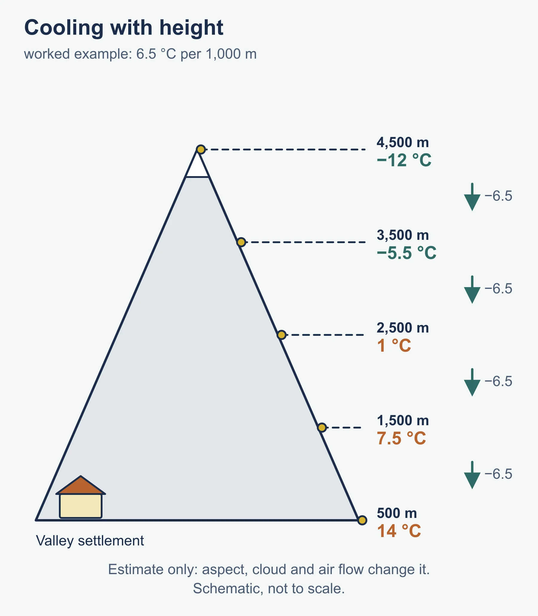
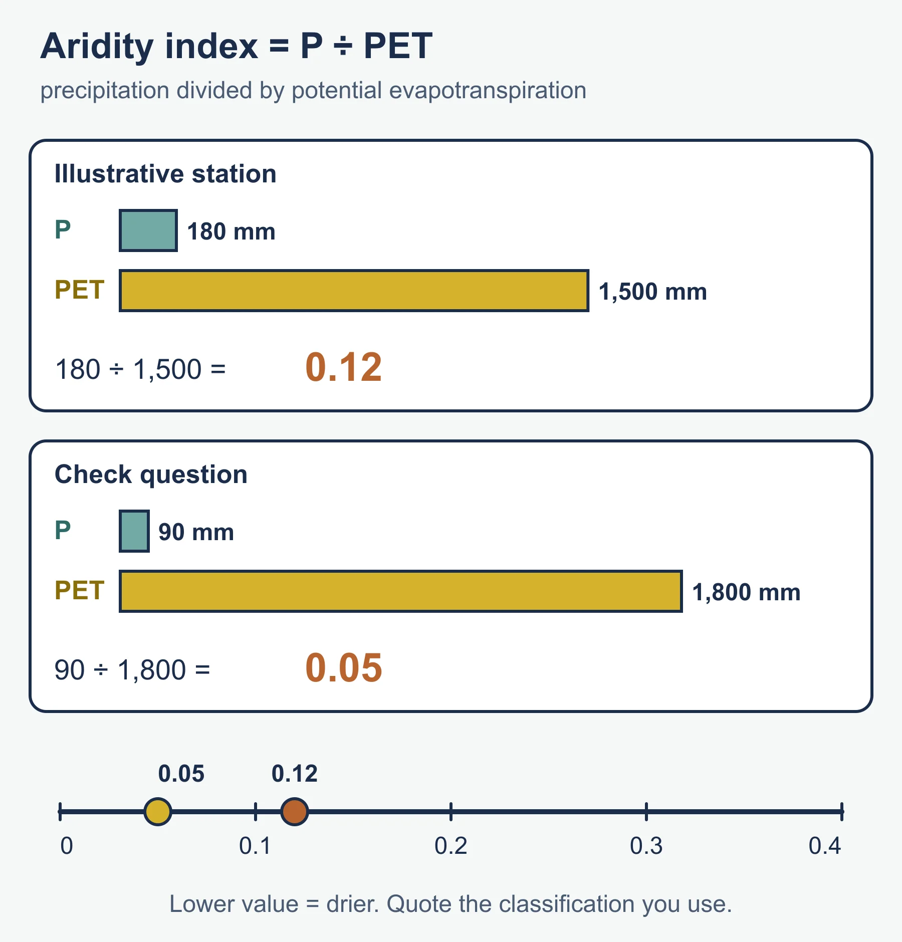
Aridity can be quantified using an aridity index, calculated as precipitation divided by potential evapotranspiration. Lower values indicate drier climates. Altitude affects temperature through the environmental lapse rate, which averages around 6.5 degrees Celsius of cooling per 1,000 m of height gained, although local conditions vary.
Identify how these characteristics are distributed globally. Hot deserts cluster in the subtropical belts of descending air, cold environments dominate high latitudes and mountain ranges rise in many latitudes. Understanding the cause of the distribution lets you explain it, which is more valuable than naming locations.
3.2 Physical processes and landscapes
Weathering and mass movement
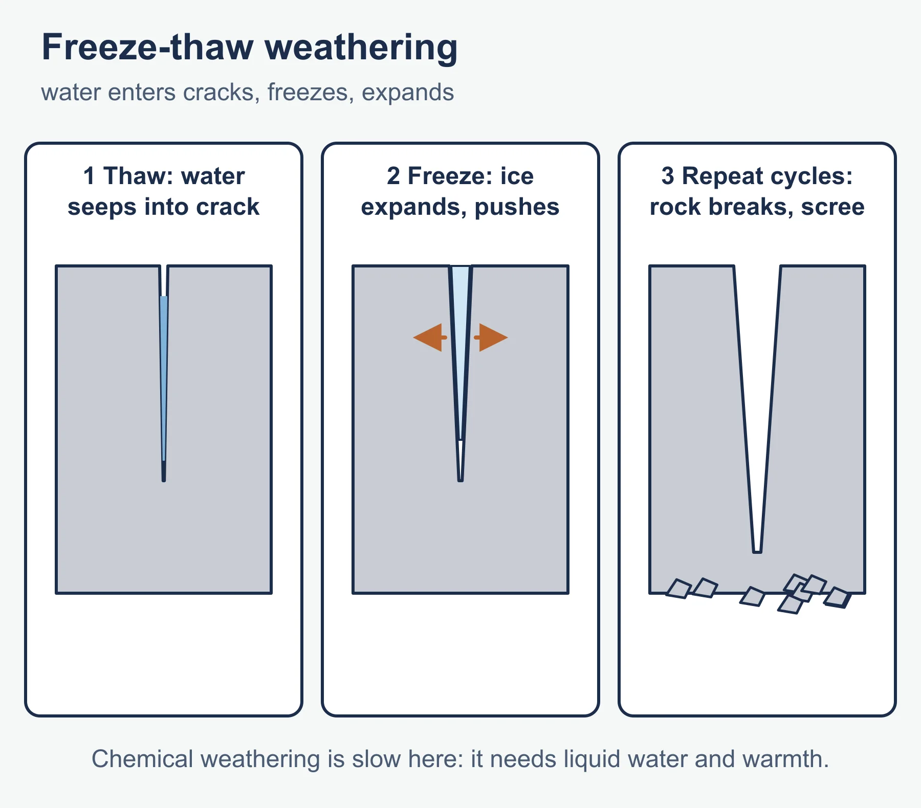
In deserts, thermal stress and salt weathering are important, with large temperature swings and evaporating groundwater leaving salts in rock pores. In cold environments, freeze-thaw weathering is vital: water enters cracks, freezes, expands and widens them, a process that produces scree. Chemical weathering is usually slow in both dry and cold settings because it needs liquid water and warmth.
Cold environment processes
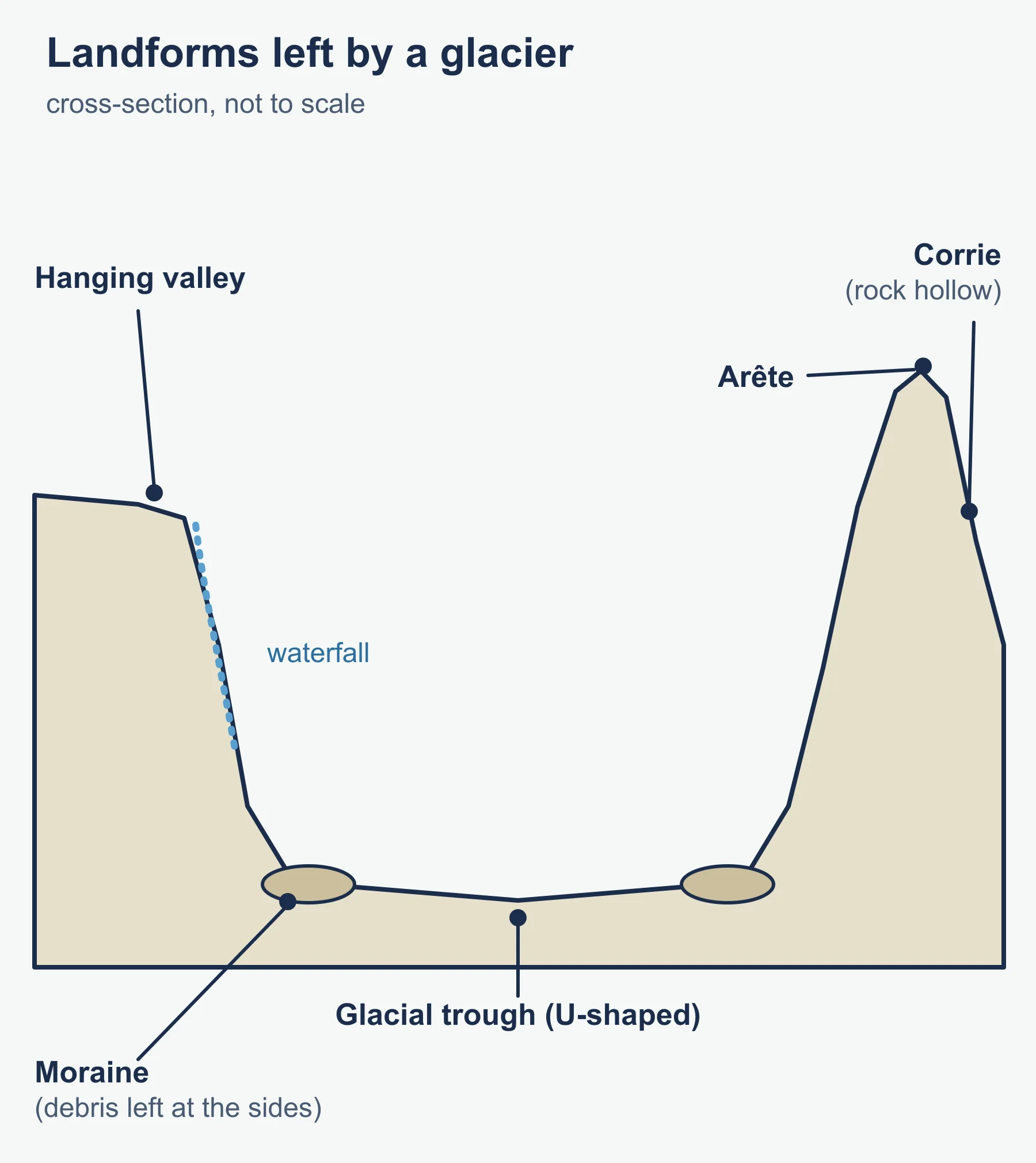
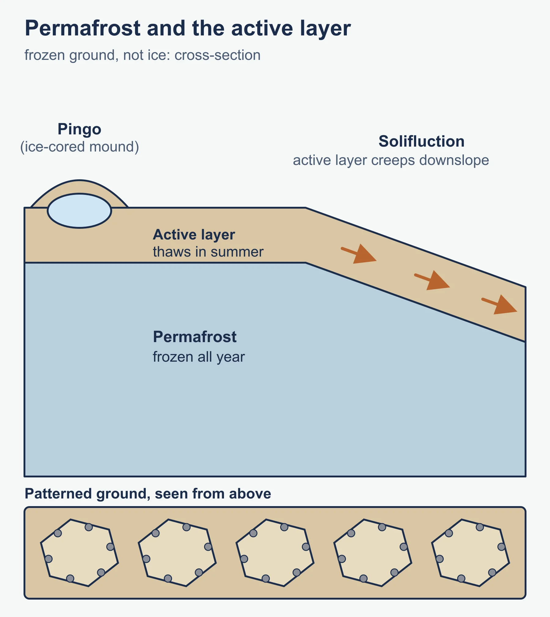
Glaciers erode by plucking and abrasion and form corries (cirques), arretes, pyramidal peaks, glacial troughs, hanging valleys and moraines. Understand the glacier as a system with accumulation, ablation and mass balance. Where ice is absent but ground remains frozen, periglacial processes apply: permafrost, the active layer that thaws in summer, frost heave, solifluction and landforms such as patterned ground and pingos. You should be able to explain how each landform forms through a sequence of steps.
Arid environment processes
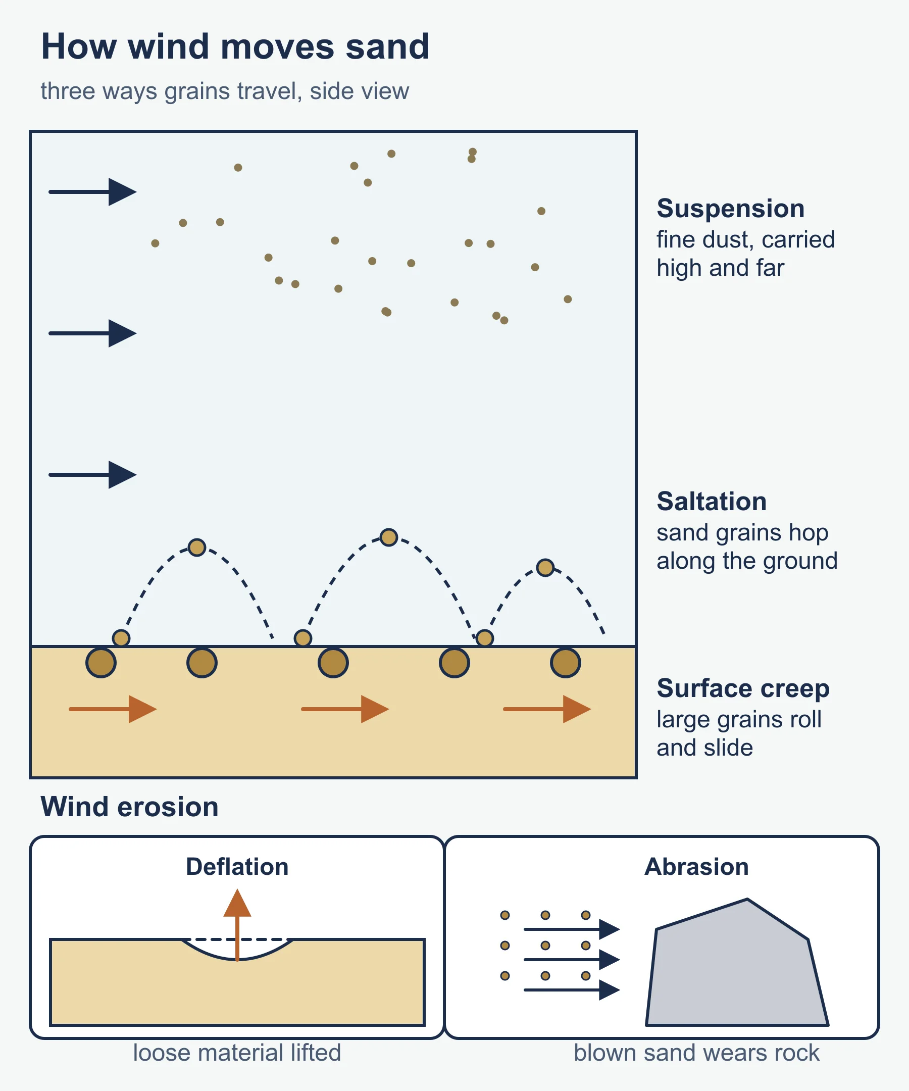
Wind transports sediment by saltation, suspension and surface creep and erodes by deflation and abrasion. Dunes form where sand supply is large and wind patterns consistent. Water, though rare, is a powerful agent: infrequent heavy rain can produce flash floods in wadis (dry valleys), alluvial fans and playas (temporary lakes). Many desert landscapes are inherited, shaped partly under wetter climates in the past, so explain landforms with reference to both present and past processes.
Mountain environments
High mountains combine steep slopes, cold, thin air and intense radiation. Zones of vegetation change with height, and slope instability produces avalanches and rockfalls.
3.3 Managing extreme environments
People live in extreme environments through adaptation, using traditional knowledge, and through technology. Traditional strategies include nomadic pastoralism, seasonal movement and building designs that suit the climate. Modern pressures include resource extraction, tourism, irrigation agriculture, infrastructure and research stations.
Management involves balancing opportunity and risk. Opportunities include minerals, energy, tourism and water storage in ice; risks include fragile ecosystems that recover slowly, permafrost thaw damaging infrastructure, desertification and increased exposure to hazards. Stakeholders include indigenous communities, governments, companies, conservation organisations and visitors, and their priorities often clash.
Strategies to consider are protected areas, visitor management, water-efficient farming, drought-resistant crops, engineering that accommodates frozen ground (for example raised structures) and international agreements for shared regions. Evaluation should consider environmental impact, cost, cultural respect and long-term sustainability.
3.4 Extreme environments futures
Climate change is the main driver of change. In cold areas, warming leads to glacier retreat, permafrost thaw, changing river regimes and new access for shipping and resource use. In arid areas, changing rainfall and rising temperatures may intensify drought, though the pattern differs from place to place. Population growth and migration into marginal lands also raise pressure.
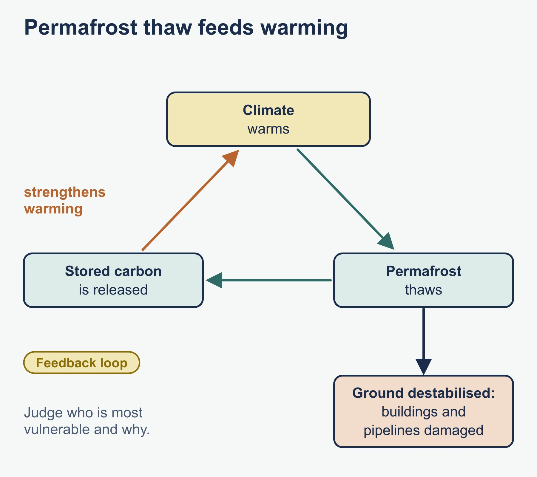
Feedbacks matter: thawing permafrost can release stored carbon, which strengthens warming. Explain such feedbacks as chains of cause and effect. Consider scenarios: a managed, adaptive future with cooperation and careful planning versus a business-as-usual future with degradation. Judge which communities are most vulnerable and what makes them more or less resilient.
Worked examples
Example 1: lapse rate
A valley settlement at 500 m above sea level has a mean annual temperature of 14 degrees Celsius. Estimate the temperature at a summit of 4,500 m using 6.5 degrees per 1,000 m.
- Height difference = 4,500 - 500 = 4,000 m.
- Cooling = 6.5 x 4 = 26 degrees Celsius.
- Estimated summit temperature = 14 - 26 = -12 degrees Celsius.
This is an estimate: aspect, cloud and local air flow cause departures from the average lapse rate.
Example 2: aridity index
An illustrative station receives 180 mm of precipitation and has potential evapotranspiration of 1,500 mm.
- Aridity index = 180 / 1,500 = 0.12.
On commonly used classifications this falls in the arid range, below semi-arid. Quote the classification you are using, because thresholds can differ between sources.
Common mistakes
- Using “extreme” as if it meant the same for everyone; qualify it by environment and people.
- Mixing up glacial and periglacial processes.
- Explaining landforms by naming them only, without a process sequence.
- Treating all deserts as hot and sandy; many are rocky, and some are cold.
- Offering management ideas without weighing costs, benefits and stakeholders.
Exam technique
Use command terms precisely. Describe a landform before explaining it, and annotate sketches where permitted. For evaluate and discuss questions, give at least two perspectives, reach a justified conclusion and keep your examples located. If a source is included, use its data explicitly, quoting figures with units.
Check your understanding
- What is the environmental lapse rate (average)? Answer: about 6.5 degrees Celsius of cooling per 1,000 m of height.
- Using that rate, how much colder is a site 2,000 m higher? Answer: 6.5 x 2 = 13 degrees Celsius colder.
- Describe freeze-thaw weathering in three steps. Answer: water enters cracks; it freezes and expands; repeated cycles widen the cracks and break the rock.
- Name two periglacial features. Answer: for example patterned ground and pingos.
- Calculate the aridity index for P = 90 mm and PET = 1,800 mm. Answer: 90 / 1,800 = 0.05.
- Why is permafrost thaw a management problem? Answer: it destabilises ground, damaging buildings and pipelines, and may release stored carbon.
- Give one reason extreme environments are slow to recover from damage. Answer: low productivity and harsh conditions mean vegetation and soils regrow slowly.
- Why might a management strategy be judged unsustainable? Answer: it may cause long-term environmental damage or ignore community needs.
Get free revision emails (optional)
Occasional emails with practice questions, worked explanations and links to free resources for the qualification and subjects you choose. No spam, and you can unsubscribe from any email. The free tools on this site never need an email.
Related resources
-
Study guides
IB DP Geography: Fieldwork (internal assessment) – Study Guide
How to plan, collect, present and evaluate fieldwork data for the IB Diploma Programme Geography internal assessment, with a worked Spearman's rank example.
Geography · International Baccalaureate · IB
Read guide -
Study guides
IB DP Geography: Option F: Food and health – Study Guide
A study guide to the Food and health option in IB DP Geography: measuring food and health, food systems and disease, stakeholders, and future security.
Geography · International Baccalaureate · IB
Read guide -
Study guides
IB DP Geography: Option A: Freshwater – Study Guide
A study guide to the Freshwater option in IB DP Geography: drainage basins, flooding, water scarcity and quality, and how water might be managed in future.
Geography · International Baccalaureate · IB
Read guide
Related articles
-
teaching
A Level tuition in Dubai: Cambridge or Pearson Edexcel International A Level?
Schools in Dubai and Abu Dhabi teach either Cambridge International AS & A Level or Pearson Edexcel International A Level. How the two are structured, why it matters for tuition, and how online classes from Lahore work.
9 October 2026
-
curriculum guides
Choosing subjects at IGCSE and A Level
How subject choices at 14 and 16 affect university options later, and how to keep pathways open without overloading a timetable.
28 July 2026
Studying this with a teacher
Working through Geography IB?
This page is free and stays free. Marlbridge is not offering Geography classes at the moment, so there is no tuition to book for it. The free study resources stay open to everyone.